
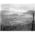
- An aerial view of Tsuen Wan (1)
An aerial view of Tsuen Wan, 1966. Fuk Loi Estate is on the right. Muk Min Ha Village can be seen below the centre of the photo.
- Aerial view of Tsuen Wan
Tsuen Wan in 1973. Muk Min Ha Village presents at the bottom centre.
- Muk Min Ha Village, Tsuen Wan (1)
Tsuen Wan in 1980. Muk Min Ha Village is on the right. Castle Peak Road and Fuk Loi Estate are on the left.
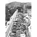
- Muk Min Ha Village, Tsuen Wan (2)
Muk Min Ha Village, Tsuen Wan, 1980.
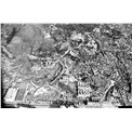
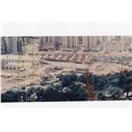
- Muk Min Ha Village, Tsuen Wan (3)
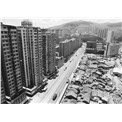
Tsuen Wan in 1980. Muk Min Ha Village is on the right. Castle Peak Road and Fuk Loi Estate are on the left.
- Muk Min Ha Village, Tsuen Wan (4)
Tsuen Wan in 1980. Muk Min Ha Village is at the centre. Fuk Loi Estate and Castle Peak Road are on the left.

- Muk Min Ha Village, Tsuen Wan (5)
Muk Min Ha Village, Tsuen Wan, 1980.
- Construction of Tsuen Wan MTR Station (1)
The construction of the Tsuen Wan MTR Station, 1980. Muk Min Ha Village is on the bottom left.
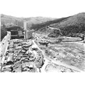
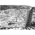
- Construction of Tsuen Wan MTR Station (2)
The Tsuen Wan MTR Station under construction, 1981. The construction site of Nan Fung Centre and Muk Min Ha Village under demolition can be seen in the photo.

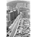
- An aerial view of Tsuen Wan (2)
Tsuen Wan in 1985. The Tsuen Wan MTR Station and Nan Fung Centre can be seen in the photo.