
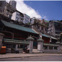
- Man Mo Temple, Sheung Wan
The Man Mo Temple in Hollywood Road, dedicated to the gods of literature (Man) and war (Mo), was erected here in 1847. Located at the Chinese residential-cum-commercial centre, the temple was built by the first group of local Chinese leaders, and was enlarged to its present size in 1851.
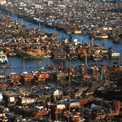
- Aberdeen
Many of Hong Kong's 60,000 boat dwellers are centred in the ancient fishing village of Aberdeen on the south side of Hong Kong Island. Visitors can tour the typhoon shelter by hiring a sampan from one of the numerous operators in the area.
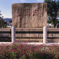
- Sung Wong Toi Garden, Ma Tau Wai
Sung Wong Toi Garden is located at the junction of Sung Wong Toi Road and Ma Tau Chung Road. It is a park of great historical value in the Kowloon City district. According to history, at the end of the Sung Dynasty (1276AD), Sung Wong Toi was originally located on a hill called "Sacred Hill" along the seashore. After the Sung Dynasty was overthrown by the Mongolian army in 1279, people inscribed the words "Sung Wong Toi" on the huge rock in memory of the fact that two Sung Emperors once took refuge there. In 1941, the Japanese army occupied Hong Kong. They burst the huge rocks of the "Sacred Hill" in order to expand the Kai Tak Airport. The rock with the words "Sung Wong Toi" remained intact by chance. In 1945, Hong Kong was liberated. To preserve the historical heritage, the Government built "Sung Wong Toi Garden" on the west of the "Sacred Hill". The huge rock was cut into a rectangle and moved into the Garden when the construction works were completed in the winter of that year.
- View of Central District and Sheung Wan
Hong Kong Club and Supreme Court can be seen near the centre. Sheung Wan is on the right.
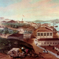
- View of Jardine Matheson & Co., Ltd. looking northwest from Causeway Bay, 28th September 1846
This view is of the premises of Jardine Matheson & Co., Ltd. looking from the northwest, with Causeway Bay in the foreground and Kellet Island on the right. The two hills, with Jardine No. 1 house on one of them, are Ewo Hill (later Lee Gardens Hill) and Morrison Hill, both now were entirely levelled.
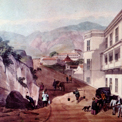
- View of Wyndham Street, Central District, from the Post Office, 29th November 1846
This view of Wyndham Street is from the Post Office, Queen's Road looking south. On the right is Hong Kong Club. The spacious building on the right further up the hill was probably the former Hotel de L'Univers, which looks and sounds ahead of its time. The flagstaff of the Harbour Office is seen on the left.
- View of Victoria (Central District) and the Victoria Harbour looking west from Murray's Battery along Queen...
This picture was drawn from higher up Battery Path. The old Hong Kong Club in Wyndham Street, with its arched porte-cochere and rectangular upper window, is visible further down Queen's Road. Behind the first projecting point on the left is today's Ice House Street. The house on the hill (with the flagstaff) was the old Harbour Office; from here Captain Pedder ruled the harbour. The projecting Pedder's Wharf, visible on the right of the picture, is now somewhere under the foundations of the Gloucester Tower.
- View of Spring Gardens, Wan Chai, 20th August 1846
Possibly one must view the hills in the background as being today's familiar landmarks such as Mount Parish (eastern end of Kennedy Road), Morrison Hill (now vanished), and even Leighton Hill. In fact, the building on the centre hill is probably "Gillespie's House" which was followed by the old Naval Hospital where the Ruttonjee Hospital is today. One interesting clue to identification of this picture lies in the rock pointing skyward on the right-hand hill; this is obviously the Lover's Rock which still stands out in sharp outlline today.
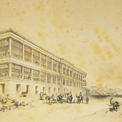
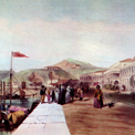
- The officer's quarters looking towards Victoria, 28th September 1846
This fine view of Murray House, soon after it was built in 1845, shows it in use as officers' quarters. The building was demolished in 1982 and reconstructed to be the present Bank of China Tower. On the road which is still under construction are groups of officers, horses and a carriage. Early buildings and Pedder's Hill are shown in the background.
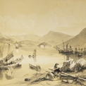
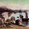
- South side of Chuck-pye-wau bay (Shek Pai Wan) looking east, 29th November 1846
This view shows part of the harbour of Aberdeen. Ap Lei Chau is on the right with Brick Hill and the present Ocean Park area behind.